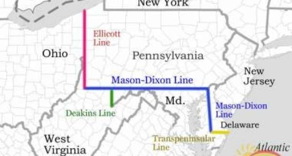
Mason and Dixon's line is a boundary line that before the American Civil War separated slave states from free states and the north of the country from the south.
This line actually goes back to colonial times. The Penn family, who were the proprietors of Pennsylvania, and the Calverts, who were the proprietors of Maryland, quarreled over the boundary line between their properties. This quarrel started in 1681.
Finally, in 1763, the families agreed to settle the argument by having their land surveyed (which means measuring it with scientific instruments). Two English astronomers, Charles Mason, and Jeremiah Dixon, were hired to do the surveying.
The work was completed in 1767, and the boundary line was named Mason and Dixon's Line. Stone markers were set up to denote the line, but they were taken by souvenir hunters. They were replaced by permanent markers.
Because Mason and Dixon's Line had become famous, it was suggested the boundary be surveyed again to prove its correctness. This was done in 1849 and again between 1900 and 1907. Mason and Dixon had been so accurate that their boundary line was not changed. The line separates Pennsylvania from Maryland and a section of West Virginia.
Mason and Dixon's Line, now considered a boundary separating northern states from southern states, remains at 39° 43' 26.3" north latitude.
